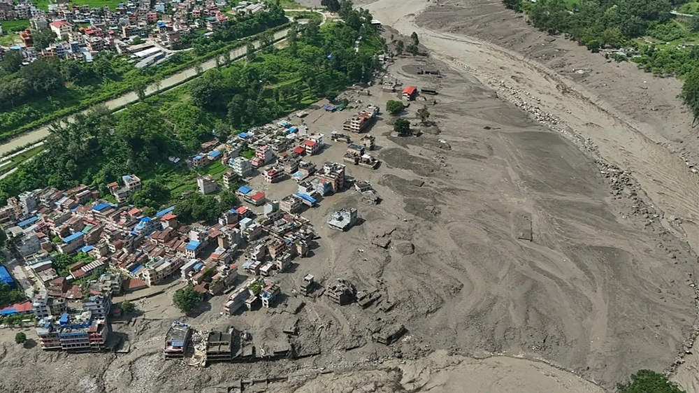
A mass of ice and rock came crashing down from about five kilometers above sea level. Minutes later, rivers rose by as much as 15 feet, and towns were buried under mud and sediment. The August 26 disaster along the Nepal-Tibet border has left more than 1,300 people missing, while the death toll continues to rise. Scientists now have a clearer picture of how the flood formed—but the reason the glacier collapsed is still not known.
What Actually Collapsed?
The first explanation was surprisingly wrong.
Early Wednesday, the U.S. Geological Survey detected what appeared to be a magnitude 4.4 earthquake about 66 kilometers north of Kathmandu. Further analysis showed that the seismic signal was not an earthquake triggering the disaster. Instead, it was caused by the impact of a glacial collapse and the debris that followed.
According to ITV’s science correspondent, the glacier collapsed at roughly 5,000 meters above sea level and may have crashed into a lake formed by an earlier landslip.
That combination was the critical moment.
The falling ice and rock displaced water and generated a huge surge of mud, ice and meltwater that then entered the river system below. This mechanism is reported as a leading explanation, but investigators are still examining exactly how the sequence unfolded.
How does a collapse high in the Himalayas turn into a flood powerful enough to destroy entire valleys? Watch the video below to see how ice, rock and water combined to create one of the region’s most devastating flash floods.
How Did a Mountain Collapse Become a Flash Flood?
The answer lies in what the water picked up on its way downhill.
Before the avalanche, river levels were around seven meters. Within minutes, they rose by another five meters, or about 15 feet. At Galchhi, the river reportedly surged by as much as nine meters in just 30 minutes.
But the flood was not simply a wall of water.
As it raced through the steep Himalayan valleys, it carried increasing amounts of rock, gravel, boulders and sediment.
That changed the physics of the disaster.
River scientist Jon Tunnicliffe of the University of Auckland explained that once the surge begins picking up solid material, its destructive power can increase dramatically. The torrent becomes a fast-moving mixture capable of smashing bridges and buildings while cutting new paths through the landscape.
In other words: The water became a weapon carrying the mountain with it.

The Damage Went Far Beyond Flooded Streets
The destruction spread through communities along the river system.
Towns and cities were left buried under as much as five feet of mud and sediment. Roads, bridges and infrastructure were damaged, while the river itself was radically reshaped.
That geography made the disaster even worse.
The narrow valleys of the Himalayas naturally concentrate the energy of moving water. At the same time, roads, settlements and hydropower infrastructure are often built along those same valley floors.
The places most useful to people are therefore also the places most exposed to a sudden mountain flood.
The human toll has been enormous. More than 1,300 people were initially reported missing across Nepal and Tibet, including foreign tourists and pilgrims. Later updates pushed the reported total even higher, while hundreds of deaths were confirmed. Because rescuers were still reaching isolated areas, the numbers remained fluid.

Video shows the moment catastrophic floods hit Nepal after glacier collapse:
Why Was There So Little Warning?
This is one of the most difficult questions.
The flood struck during the monsoon season, but significant rainfall does not appear to have been the trigger, according to ITV. The event originated much higher in the mountains, making it fundamentally different from a conventional rain-driven flood.
That distinction matters for early-warning systems.
A community may be prepared for rising river levels after heavy rain. It is much harder to anticipate an abrupt chain reaction that begins kilometers above them with a collapse of ice, rock and water.
By the time the river below starts rising dramatically, there may be very little time left.
Could This Happen Again?
Scientists are not saying that every glacier in the Himalayas is about to collapse.
But they are warning that the broader environment is changing.
Across the Hindu Kush Himalaya, glaciers are retreating, permafrost is degrading, new lakes are forming and previously protected slopes are becoming exposed and potentially unstable.
Professor Tunnicliffe said climate change can amplify existing hazards by changing the thresholds at which one process triggers another.
That does not mean climate change has been proven to be the direct cause of this particular glacier collapse.
ITV’s report is explicit: the exact reason the glacier collapsed is not yet known. Scientists are investigating a possible indirect link to climate change, but that remains an area of study rather than a settled conclusion.
The Danger May Continue After the First Wave
Perhaps the most important detail is that the first flood may not be the end of the story.
Once enormous amounts of sediment are deposited in a river system, they can block tributaries, raise riverbeds, redirect channels and form temporary dams.
That creates new hazards days, weeks or even years after the original event.
So the real danger is not simply that a glacier collapses once.
It is that one collapse can rebuild the landscape in dangerous ways, creating the conditions for the next disaster.

The Nepal floods were not simply a case of heavy rain overwhelming a river. A collapse high in the Himalayas appears to have triggered a chain reaction: ice and rock surged into a lake and river system, water levels rose dramatically, and the resulting torrent gathered enough sediment to become a destructive mixture capable of reshaping entire valleys. Exactly why the glacier collapsed remains under investigation. But scientists are warning that a warmer, less stable Himalayan environment could make these cascading hazards increasingly difficult to predict.