
For centuries, sailors crossing between the Atlantic and Pacific faced a terrifying choice: go around the southern tip of South America. Before the Panama Canal opened in 1914, there was no easy shortcut. Ships had to pass Cape Horn, where powerful winds, enormous waves, freezing water, rocky shoals and drifting icebergs could turn an ordinary voyage into a fight for survival. Hundreds of ships went down in these waters. Even Charles Darwin, sailing aboard HMS Beagle in 1832, experienced the violence of the Horn firsthand. Today, satellites can look down on the same stretch of ocean that once terrified generations of sailors.
Before The Panama Canal, There Was No Easy Way Around
Cape Horn sits at the southern tip of Chile’s Tierra del Fuego archipelago, near the point where the Atlantic and Pacific meet. Today, a modern ship can avoid the region by using the Panama Canal, but that option did not exist for the sailors who carried people and cargo between the world’s two great oceans during the age of sail.
For centuries, ships traveling between the Atlantic and Pacific had to make the long journey around the bottom of South America. The route was strategically important for global trade, but it also became infamous among sailors. Rounding Cape Horn meant pushing deep into the Southern Ocean, where the weather could change violently and there was little shelter from the open sea. NASA describes the waters around the cape as a combination of hazards that made the region a graveyard for ships.
The danger was not caused by one single feature. Cape Horn was frightening because several dangerous forces came together in the same place. A ship could be battling powerful winds while also dealing with huge waves, freezing temperatures, rocky coastlines and ice drifting north from Antarctica.
Discover the terrifying legend of Cape Horn, the world’s most dangerous maritime passage. From monstrous waves to tragic shipwrecks, explore how this isolated rock shaped global trade and tested the limits of human endurance. Are you brave enough to face the “end of the world”? Watch now to find out!
The Ocean Floor Helped Create A Nightmare
One of the strangest reasons Cape Horn can produce such violent seas is hidden beneath the surface.
Southwest of the cape, the ocean floor rises dramatically. NASA notes that the seabed drops to about 4,020 meters before rising to roughly 100 meters within only a few kilometers. When this underwater geography interacts with powerful ocean currents and winds, the result can be enormous waves.
The winds made matters even worse. Cape Horn lies in the latitudes sailors traditionally called the Furious Fifties, a belt of powerful westerly winds that circle the Southern Hemisphere with relatively little land to slow them down. Farther north are the Roaring Forties, while farther south lie the even more severe Screaming Sixties. NOAA notes that the Southern Hemisphere’s lack of large land masses allows these winds to remain particularly powerful.
For a modern observer looking at a satellite image, the geography can seem almost peaceful. For a sailor on a wooden ship with limited navigation and no modern weather forecasting, the same environment could become terrifying within hours.
And then there was the cold. The waters around Cape Horn are close to Antarctica, and icebergs can drift north through the Drake Passage. A ship did not have to collide with one to be in danger. Freezing water, heavy precipitation, rough seas and poor visibility could make an already difficult passage even harder.

Charles Darwin Saw The Horn At Its Worst
One of the most famous people to experience Cape Horn’s violence was Charles Darwin.
In 1832, Darwin was traveling aboard HMS Beagle during the expedition that would later become central to his scientific career. As the ship approached Cape Horn just before Christmas, the crew initially experienced surprisingly favorable weather. They managed to round the cape, but the calm did not last.
A gale soon came directly toward the ship. The crew turned back toward the coast, and Darwin described seeing the notorious promontory surrounded by mist, wind and water. Rain and hail swept across the ship with such force that Captain Robert FitzRoy decided to seek shelter in Wigwam Cove.
The episode is revealing because the Beagle was not an inexperienced vessel wandering blindly into unknown waters. FitzRoy was a skilled naval officer, and Darwin was traveling as part of a major scientific expedition. Yet even a well-prepared ship could be forced to retreat when Cape Horn’s weather turned against it.
For sailors of the age, this was the reality of rounding the Horn. A successful passage did not necessarily mean defeating the sea. Sometimes it simply meant surviving long enough for the weather to give you another chance.
Hundreds Of Ships Were Lost Around Cape Horn
Cape Horn was first rounded by the Dutch navigator Willem Schouten in 1616. From then on, the route became an important passage for ships moving between the world’s oceans. But the same route that connected distant economies also became notorious for shipwrecks. NASA reports that hundreds of ships have gone down near Cape Horn since Schouten’s voyage.
The risks were especially severe during the era of sailing ships. A vessel caught in headwinds could spend days or weeks struggling to make progress. Heavy seas could damage sails and rigging, while storms could push ships toward rocky shores. In freezing conditions, even a relatively minor accident could become life-threatening.
The greatest danger was the combination of isolation and weather. There was no satellite forecast warning a captain that a major storm was approaching, no modern engine capable of simply turning a ship away from danger, and no rapid rescue service waiting nearby.
A sailor who went overboard in those waters faced an especially grim situation. Even if the crew saw what happened, the combination of waves, cold water and a moving sailing ship made rescue extraordinarily difficult.
This is why Cape Horn became more than a geographical landmark. It became a test of seamanship and endurance. To round the Horn was an achievement; to do it repeatedly was a badge of experience.

Then The Panama Canal Changed Everything
The age of Cape Horn’s greatest importance began to fade when the Panama Canal opened in 1914.
Instead of sailing thousands of miles around the southern tip of South America, ships could pass through the narrow canal connecting the Atlantic and Pacific. The new route dramatically reduced the need for commercial vessels to face the waters around Cape Horn. NASA notes that the canal greatly reduced the number of ships that needed to make the dangerous passage.
The change was enormous. A route that had once been essential to international trade became largely unnecessary for ordinary commercial shipping.
But Cape Horn did not become harmless.
The same geography still exists. The same Southern Ocean winds still sweep across the region, and the same cold waters and storms still surround the cape. Modern ships have far better navigation, weather forecasting, communications and safety equipment, but the ocean itself has not become more forgiving.
That is why rounding Cape Horn remains an important achievement for sailors, particularly those aboard traditional sailing vessels and ocean-racing yachts. What was once a commercial necessity has become, for some, a deliberate test of skill and endurance.
The Place That Once Terrified Sailors Now Looks Peaceful From Space
There is something almost strange about seeing Cape Horn from above.
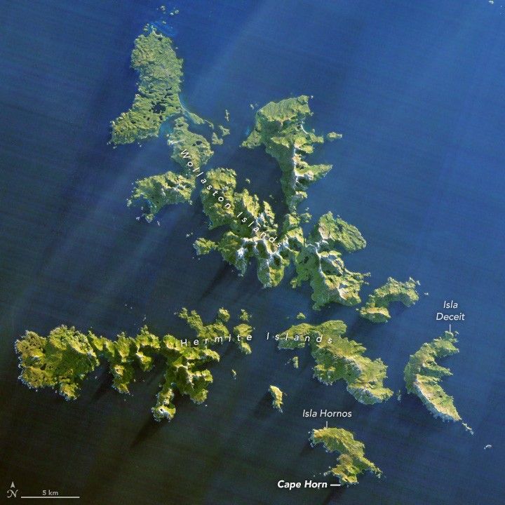
NASA’s Landsat 8 satellite photographed Cape Horn and the nearby Wollaston and Hermite Islands on July 12, 2014. From hundreds of kilometers above Earth, the region appears remote and beautiful, its rugged islands surrounded by dark ocean. Nothing in the image immediately reveals the storms, freezing water and enormous waves that made the area so feared by generations of sailors.
That contrast may be the most remarkable part of Cape Horn’s story.
For centuries, sailors saw the cape from the deck of a ship, often through rain, mist and spray. They measured their progress in miles, watched the wind and waves, and hoped the weather would allow them to pass safely. Today, a satellite can observe the same landscape from space in a single image. The technology has changed completely. The ocean has not.
Cape Horn is no longer the unavoidable gateway between the Atlantic and Pacific that it once was. The Panama Canal transformed global shipping and removed much of the commercial need to round the Horn. Yet the cape remains a powerful reminder of what ocean travel once demanded—and why simply making it around the bottom of South America could be considered an achievement.
For centuries, Cape Horn stood between sailors and the destination they were trying to reach. Powerful winds, enormous waves, freezing water, rocky shores and drifting ice made the southern tip of South America one of the most feared passages on Earth. Hundreds of ships were lost in its waters, while even Charles Darwin’s HMS Beagle was forced to seek shelter during a violent storm. The Panama Canal eventually made the journey largely unnecessary, but Cape Horn never became less formidable. Today, satellites see the same dangerous waters from space—a peaceful view of a place that once terrified sailors.
This story draws primarily on NASA Earth Observatory’s account of Cape Horn, including the geography, weather conditions and maritime history that made the passage so dangerous. NASA’s satellite imagery provides a remarkable modern view of a region that generations of sailors experienced from the deck of a ship. Source: https://science.nasa.gov/earth/earth-observatory/cape-horn-a-mariners-nightmare-91472/