For centuries, maps showed a small island sitting in the Gulf of Mexico off the coast of Mexico’s Yucatán Peninsula. It had a name, a location and a surprisingly consistent place in the records of European and Mexican cartographers. Then scientists went looking for it. They found open water, a seabed nearly 1,500 meters deep and no obvious trace that an island had ever been there. Even stranger, the missing island was tied to one of the most valuable stretches of ocean in the region.
The Island That Appeared on Ancient Maps
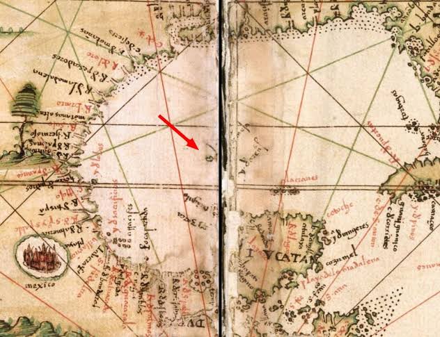
Bermeja was described as a small island somewhere north of the Yucatán Peninsula, in what is now the Gulf of Mexico. One of the earliest references appeared in the 16th century, and the island continued to appear on maps for generations. Some maps used variations such as Bermejo or Vermeja, but the basic idea remained the same: a small piece of land existed offshore.
Its name even seemed to describe what sailors were supposed to have seen. The Spanish word bermejo refers to a reddish or russet color, and early descriptions portrayed the island as something that could be recognized from a distance. For cartographers working centuries before satellites, sonar and modern navigation, that kind of description could become part of the geographic record surprisingly easily.
The strange part was how long the island remained on maps. It was not simply mentioned once and forgotten. It continued to be reproduced by later mapmakers, creating the impression that generations of people had independently accepted the same piece of geography as real.
Then modern technology arrived—and the island became much harder to find.
Ever wonder why an entire island vanished from maps? From 16th-century cartography to modern oil conspiracies, join me as we explore the mystery of Bermeja. Was it a mapping error, climate change, or a secret CIA plot? Dive into the full investigation and decide for yourself! Watch now.
Then the Search Began
By the late 20th century, Bermeja had become a geographic problem. Reports placed it around latitude 22°33′ north and longitude 91°22′ west, roughly 200 kilometers from the Yucatán coast. But when researchers began checking the location, there was no island waiting for them.
A Spanish research vessel searched the area in 1997 and found no trace. Twelve years later, researchers from the National Autonomous University of Mexico, or UNAM, conducted a much more extensive investigation. Their work combined cartographic research, aerial observation and an oceanographic expedition aboard the research vessel Justo Sierra.
The ocean floor produced the most striking result. At the coordinates traditionally assigned to Bermeja, the water was about 1,472 meters deep and the seabed was described as flat. Researchers reported finding neither an island nor remnants that would indicate one had once stood there. Their analysis also concluded that an island had not existed at that precise location for more than 5,300 years.
An island that had appeared on maps for centuries had effectively vanished from the physical world.

How Can an Island Disappear?
That question is what turned Bermeja into a lasting mystery. One possibility is that the island never existed where the maps said it did. Early navigators had limited instruments, and an error in position could be copied from one chart to another until the mistake became accepted as fact. The long life of Bermeja on maps does not necessarily mean every mapmaker independently saw the island.
Another possibility is that Bermeja existed somewhere other than the traditional coordinates. The UNAM researchers did not completely rule out the idea that the island might have been located elsewhere. They also considered whether geological processes could have altered or removed a landmass over a very long period, although their measurements found no evidence of an island at the established location.
The history of the maps itself may provide part of the explanation. A recent 2026 study published by UNAM’s Faculty of Philosophy and Letters treats Bermeja as a particularly revealing example of how cartographic errors, geographic myths and political interests can reinforce one another over time. In that interpretation, the mystery is not merely about a missing island—it is about how a place can become real on paper even when its physical existence is uncertain.
The Island Was Worth More Than a Piece of Land
Bermeja might have remained a fascinating cartographic oddity if nothing valuable had been associated with its location. But its supposed existence had implications far beyond geography.
Because islands can affect maritime boundaries, Bermeja’s location became connected to the division of offshore waters between Mexico and the United States. Researchers and Mexican officials examined the island partly because its existence could have affected the boundaries used to define economic rights in the Gulf of Mexico.
That mattered because the Gulf is rich in oil and gas. Historic Mysteries reports estimates that the surrounding area could contain roughly 22.5 billion barrels of oil, making the question of where maritime boundaries should fall more than an academic argument. The 2009 UNAM investigation was presented to Mexico’s Congress in part because of the strategic importance of the region and its natural resources.
Suddenly, the question changed from “Where did an old island go?” to something much larger: “What would it mean if that island had actually been there?”
The Conspiracy Theory
That combination of a missing island, valuable resources and an international maritime boundary inevitably produced conspiracy theories. One popular claim holds that Bermeja was deliberately destroyed so that Mexico would not gain the additional maritime territory associated with it. Some versions go even further and accuse American intelligence agencies of secretly removing the island.
There is no solid evidence establishing that explanation as fact. The researchers who investigated the site did not report finding signs of a deliberate destruction, and the scientific findings offered much more ordinary possibilities, including mapping errors or a mistaken location. The conspiracy remains part of Bermeja’s cultural history, but it should not be confused with a proven explanation.
And perhaps that is what makes the story more interesting. Bermeja does not need a secret explosion to be strange. The documented part is already remarkable: people kept placing an island on maps for centuries, modern researchers went to the supposed location, and the ocean floor did not cooperate with the maps.

The Island That May Never Have Been There
Today, Bermeja occupies an unusual place between history, science and myth. Researchers have failed to find the island at its traditional coordinates, and modern oceanographic investigation found no physical evidence that an island had existed there in the recent geological past. Yet the old maps remain, preserving the image of a small red island that generations of cartographers believed belonged in the Gulf of Mexico.
That leaves the central mystery unresolved in a more subtle way than a simple disappearance. Perhaps Bermeja was misplaced. Perhaps an old observation was misunderstood and repeated. Perhaps the island existed somewhere else entirely. What scientists can say with confidence is that the island described by those historic maps is not sitting at the coordinates where generations of maps placed it.
In the end, Bermeja may be one of history’s clearest reminders that maps are records of what people believed they knew—not always proof of what physically existed.
For roughly four centuries, Bermeja appeared on maps as a small island in the Gulf of Mexico. Then modern researchers went to its supposed location and found nothing but deep, flat ocean floor. The mystery became even more intriguing because the island’s existence could have affected maritime boundaries in an oil-rich region. Conspiracy theories followed, but no evidence has established deliberate destruction. What remains is a stranger and more enduring puzzle: how did an island become part of the world’s geography for generations when modern science could find no trace of it where the maps said it was?
P.S. This article is based primarily on Historic Mysteries’ account of Bermeja, with the island’s history and modern investigation cross-checked against reporting on the 2009 UNAM expedition and a 2026 UNAM geographical study. Source: Historic Mysteries — https://www.historicmysteries.com/unexplained-mysteries/mystery-of-bermeja-the-mexican-island-that-vanished/40031/